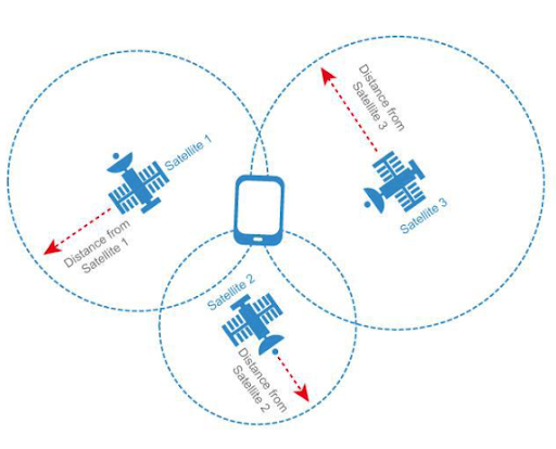
'/%3e%3cpath%20d='M111.397%20125.67L105.593%20135.713L99.7989%20145.753L95.1406%20137.679L94.0069%20135.713L91.5066%20131.394C91.2954%20131.003%2091.0745%20130.62%2090.8342%20130.239L90.7735%20130.129L75.0581%20102.898V100.519C75.0581%2097.7732%2077.2837%2095.5476%2080.0292%2095.5476H94.0069L95.1406%2097.5163L111.397%20125.67Z'%20fill='white'/%3e%3cpath%20d='M72.2629%2076.2687C72.2629%2083.3627%2078.0137%2089.1134%2085.1076%2089.1134C92.2015%2089.1134%2097.9523%2083.3627%2097.9523%2076.2687C97.9523%2069.1748%2092.2015%2063.4241%2085.1076%2063.4241C78.0137%2063.4241%2072.2629%2069.1748%2072.2629%2076.2687Z'%20fill='url(%23paint1_linear_846_105547)'/%3e%3cpath%20d='M166.012%20105.461L166.012%20165.848C166.012%20171.375%20170.493%20175.856%20176.021%20175.856C181.549%20175.856%20186.03%20171.375%20186.03%20165.848L186.03%20105.461C186.03%2099.9332%20181.549%2095.4521%20176.021%2095.4521C170.493%2095.4521%20166.012%2099.9332%20166.012%20105.461Z'%20fill='url(%23paint2_linear_846_105547)'/%3e%3cpath%20d='M146.11%20125.782C148.653%20121.377%20155.386%20123.182%20155.386%20128.267V175.877H135.306V144.499L140.374%20135.714L146.11%20125.782Z'%20fill='url(%23paint3_linear_846_105547)'/%3e%3cpath%20d='M95.1412%20137.681V145.755C95.1475%20150.77%2093.8956%20155.707%2091.5%20160.113L90.7718%20161.358C87.1636%20167.312%2081.6081%20171.835%2075.0466%20174.161V102.9L90.7621%20130.131L90.8228%20130.241L91.4952%20131.396L93.9955%20135.715L95.1412%20137.681Z'%20fill='url(%23paint4_linear_846_105547)'/%3e%3cpath%20d='M196.133%2095.5476H176.053C170.508%2095.5476%20166.012%20100.043%20166.012%20105.589C166.012%20111.134%20170.508%20115.63%20176.053%20115.63H196.133C201.679%20115.63%20206.175%20111.134%20206.175%20105.589C206.175%20100.043%20201.679%2095.5476%20196.133%2095.5476Z'%20fill='white'/%3e%3cdefs%3e%3clinearGradient%20id='paint0_linear_846_105547'%20x1='125.887'%20y1='95.5476'%20x2='125.887'%20y2='165.835'%20gradientUnits='userSpaceOnUse'%3e%3cstop%20stop-color='%234D77FF'/%3e%3cstop%20offset='1'%20stop-color='white'/%3e%3c/linearGradient%3e%3clinearGradient%20id='paint1_linear_846_105547'%20x1='85.1076'%20y1='63.4241'%20x2='85.1076'%20y2='89.1134'%20gradientUnits='userSpaceOnUse'%3e%3cstop%20stop-color='%234D77FF'/%3e%3cstop%20offset='1'%20stop-color='white'/%3e%3c/linearGradient%3e%3clinearGradient%20id='paint2_linear_846_105547'%20x1='186.03'%20y1='95.4521'%20x2='186.03'%20y2='175.856'%20gradientUnits='userSpaceOnUse'%3e%3cstop%20stop-color='%234D77FF'/%3e%3cstop%20offset='1'%20stop-color='white'/%3e%3c/linearGradient%3e%3clinearGradient%20id='paint3_linear_846_105547'%20x1='145.346'%20y1='109.718'%20x2='145.346'%20y2='175.877'%20gradientUnits='userSpaceOnUse'%3e%3cstop%20stop-color='%234D77FF'/%3e%3cstop%20offset='1'%20stop-color='white'/%3e%3c/linearGradient%3e%3clinearGradient%20id='paint4_linear_846_105547'%20x1='85.0939'%20y1='102.9'%20x2='85.0939'%20y2='174.161'%20gradientUnits='userSpaceOnUse'%3e%3cstop%20stop-color='%234D77FF'/%3e%3cstop%20offset='1'%20stop-color='white'/%3e%3c/linearGradient%3e%3c/defs%3e%3c/svg%3e)
Outdoor Digital Maps and Business Applications
1. Introduction
Outdoor digital maps are becoming an important tool helping businesses effectively manage resources, people, and business operations. Businesses across various sectors such as real estate, industrial parks, construction, tourism, and security can leverage digital map technology to optimize operational processes.
2. Applications of Outdoor Digital Maps
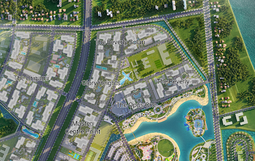
2.1. Map Planning, Infrastructure Status Display
Construction Progress Management
- Businesses can use digital maps to update construction progress in real-time.
- Satellite imagery and GIS data can support remote monitoring of projects, helping to minimize risks and optimize on-site inspection costs.
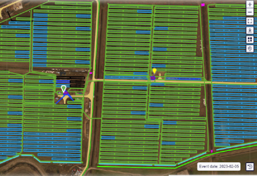
Managing Land Plot Status in Industrial Parks
- Provides detailed maps displaying the status of each land plot: leased, for sale, vacant, or under construction.
- Helps investors gain a more visual understanding of land use status and make quick decisions.
2.2. Creating Marketing Maps for Urban Areas, Tourist Zones, Industrial Parks
- Using digital maps to display customer attractions such as shopping centers, restaurants, hotels, and entertainment venues.
- Businesses can deploy geographically targeted advertising, reaching the right customer segments.
- Analyzing foot traffic to optimize billboard placement and promotional areas.
2.3. Employee Location Management
Location-Based Attendance
- Applying digital maps to verify location when employees check in, preventing fraud.
- The system automatically records working hours and generates accurate reports.
Location-Based Work Reporting
- Employees can update work reports directly from the field, making it easier for managers to track progress.
- Digital maps allow for pinpointing the location where work is performed, improving monitoring efficiency.
2.4. Equipment and Camera Location Management
- Tracking the location of IoT devices, surveillance cameras, and security infrastructure.
- Digital maps help display the coverage area of each camera, supporting remote monitoring and maintenance of equipment.
- Alert systems when devices are moved or experience issues.
3. Outdoor Digital Map Platforms and Solutions
3.1. Google Maps
- Provides powerful APIs for businesses to integrate maps, directions, and geographic data.
- Supports Street View for detailed on-site observation.
- Suitable for e-commerce applications, logistics, and location management.
3.2. Esri ArcGIS
- Dedicated GIS mapping solution for large businesses, governments, and research organizations.
- Supports spatial analysis, advanced geographic data, and complex data visualization.
- Widely used in urban planning, environmental protection, and infrastructure management.
3.3. OpenStreetMap (OSM)
- Open-source mapping platform with rich data that can be customized according to business needs.
- Suitable for systems that don't want to depend on commercial services.
- Supports integration with many GIS technologies.
4. Conclusion
Outdoor digital maps are not just tools for displaying locations but also help businesses optimize resource management, improve work efficiency, and enhance customer experience. Applying digital maps to real-world problems will help businesses save costs and enhance competitiveness in the digital age.
However, with specific business challenges, existing map platforms may not fully meet all business needs. Building a custom map system, tailored to industry-specific requirements, will help businesses maximize spatial data usage, improve integration with internal systems, and optimize operational performance. A specialized digital map solution can provide a sustainable competitive advantage in the long term.