'/%3e%3cpath%20d='M111.397%20125.67L105.593%20135.713L99.7989%20145.753L95.1406%20137.679L94.0069%20135.713L91.5066%20131.394C91.2954%20131.003%2091.0745%20130.62%2090.8342%20130.239L90.7735%20130.129L75.0581%20102.898V100.519C75.0581%2097.7732%2077.2837%2095.5476%2080.0292%2095.5476H94.0069L95.1406%2097.5163L111.397%20125.67Z'%20fill='white'/%3e%3cpath%20d='M72.2629%2076.2687C72.2629%2083.3627%2078.0137%2089.1134%2085.1076%2089.1134C92.2015%2089.1134%2097.9523%2083.3627%2097.9523%2076.2687C97.9523%2069.1748%2092.2015%2063.4241%2085.1076%2063.4241C78.0137%2063.4241%2072.2629%2069.1748%2072.2629%2076.2687Z'%20fill='url(%23paint1_linear_846_105547)'/%3e%3cpath%20d='M166.012%20105.461L166.012%20165.848C166.012%20171.375%20170.493%20175.856%20176.021%20175.856C181.549%20175.856%20186.03%20171.375%20186.03%20165.848L186.03%20105.461C186.03%2099.9332%20181.549%2095.4521%20176.021%2095.4521C170.493%2095.4521%20166.012%2099.9332%20166.012%20105.461Z'%20fill='url(%23paint2_linear_846_105547)'/%3e%3cpath%20d='M146.11%20125.782C148.653%20121.377%20155.386%20123.182%20155.386%20128.267V175.877H135.306V144.499L140.374%20135.714L146.11%20125.782Z'%20fill='url(%23paint3_linear_846_105547)'/%3e%3cpath%20d='M95.1412%20137.681V145.755C95.1475%20150.77%2093.8956%20155.707%2091.5%20160.113L90.7718%20161.358C87.1636%20167.312%2081.6081%20171.835%2075.0466%20174.161V102.9L90.7621%20130.131L90.8228%20130.241L91.4952%20131.396L93.9955%20135.715L95.1412%20137.681Z'%20fill='url(%23paint4_linear_846_105547)'/%3e%3cpath%20d='M196.133%2095.5476H176.053C170.508%2095.5476%20166.012%20100.043%20166.012%20105.589C166.012%20111.134%20170.508%20115.63%20176.053%20115.63H196.133C201.679%20115.63%20206.175%20111.134%20206.175%20105.589C206.175%20100.043%20201.679%2095.5476%20196.133%2095.5476Z'%20fill='white'/%3e%3cdefs%3e%3clinearGradient%20id='paint0_linear_846_105547'%20x1='125.887'%20y1='95.5476'%20x2='125.887'%20y2='165.835'%20gradientUnits='userSpaceOnUse'%3e%3cstop%20stop-color='%234D77FF'/%3e%3cstop%20offset='1'%20stop-color='white'/%3e%3c/linearGradient%3e%3clinearGradient%20id='paint1_linear_846_105547'%20x1='85.1076'%20y1='63.4241'%20x2='85.1076'%20y2='89.1134'%20gradientUnits='userSpaceOnUse'%3e%3cstop%20stop-color='%234D77FF'/%3e%3cstop%20offset='1'%20stop-color='white'/%3e%3c/linearGradient%3e%3clinearGradient%20id='paint2_linear_846_105547'%20x1='186.03'%20y1='95.4521'%20x2='186.03'%20y2='175.856'%20gradientUnits='userSpaceOnUse'%3e%3cstop%20stop-color='%234D77FF'/%3e%3cstop%20offset='1'%20stop-color='white'/%3e%3c/linearGradient%3e%3clinearGradient%20id='paint3_linear_846_105547'%20x1='145.346'%20y1='109.718'%20x2='145.346'%20y2='175.877'%20gradientUnits='userSpaceOnUse'%3e%3cstop%20stop-color='%234D77FF'/%3e%3cstop%20offset='1'%20stop-color='white'/%3e%3c/linearGradient%3e%3clinearGradient%20id='paint4_linear_846_105547'%20x1='85.0939'%20y1='102.9'%20x2='85.0939'%20y2='174.161'%20gradientUnits='userSpaceOnUse'%3e%3cstop%20stop-color='%234D77FF'/%3e%3cstop%20offset='1'%20stop-color='white'/%3e%3c/linearGradient%3e%3c/defs%3e%3c/svg%3e)
Overview of Digital Map Platforms
Digital Maps are one of the core technologies in many modern fields, from navigation, urban planning to e-commerce and resource management. The development of digital map platforms has enabled businesses and individuals to leverage geographic data to optimize operations and enhance user experiences.
Based on the scope of application, digital maps can be classified into two main groups: Outdoor Digital Maps and Indoor Digital Maps.
Outdoor Digital Maps
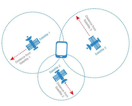
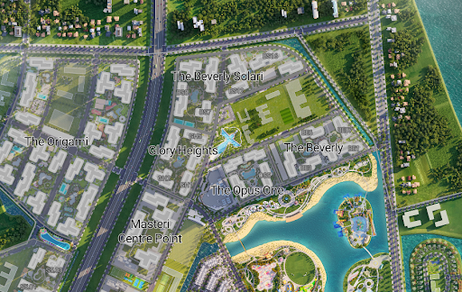
Outdoor digital maps are map systems that provide information about terrain, traffic, and outdoor objects such as streets, buildings, rivers, residential areas, industrial zones, and public places. This type of map is widely applied in navigation, traffic management, spatial analysis, urban & industrial zone planning.
Characteristics of outdoor digital maps
- Wide geographic coverage: Covering from industrial zones, urban areas to global scale, suitable for wide-range applications.
- Integration with AI technology and big data: Predicting optimal routes, analyzing user movement behavior.
- Diverse applications: Used for personal navigation, vehicle management, logistics, e-commerce, and ride-hailing services.
Solutions for building outdoor digital maps
Depending on the actual needs of businesses, outdoor map applications can be built based on 2 solutions:
| Existing Map Platforms | Building Custom Digital Maps | |
| Map data | Global coverage | Regional coverage |
| Customization capability | Limited, difficult to edit interface and data | Very high. Can be customized according to actual images or planning/marketing images. |
| Real-time traffic data | Yes. Updated in real-time. | Not available by default. Need to integrate third-party data. |
| Application use cases | - Traffic, navigation. | - Planning and management of industrial zones, urban areas. |
Indoor Digital Maps
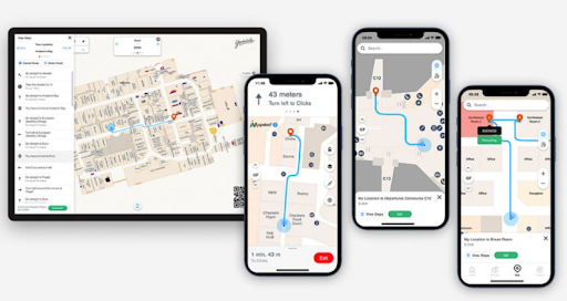
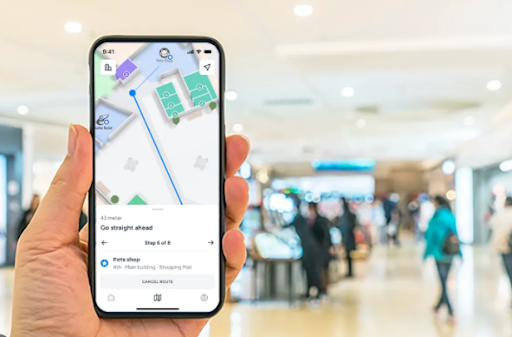
Indoor Digital Mapping is a solution that helps position and navigate in enclosed spaces such as shopping centers, hospitals, airports, office buildings. Some features of indoor digital maps:
- Positioning in environments without GPS signals.
- Support for navigation in multi-story buildings.
- Combination of Wi-Fi, Bluetooth, sensor technologies to determine location.
- Applied in space management, security, and customer experience.
Development Trends
Digital maps are not just navigation tools but have become important platforms in many business sectors. Development trends in the application of digital maps for businesses include:
- 3D Maps & AR: Applied in real estate, tourism, urban design to enhance interactive experiences.
- Integration with IoT: Vehicle management, asset tracking in logistics, smart device management in factories.
- Maps for supply chain & logistics: Help businesses monitor transportation routes, manage warehouses, optimize operational costs.
- Applications in e-commerce: Optimize delivery services, locate the nearest stores, enhance customer experience with accurate positioning.
- Security & monitoring maps: Applied in urban security, monitoring areas that need surveillance, supporting emergency coordination.
Choosing the right platform will help businesses optimize operations and create competitive advantages in the digital age.